US Route 6 is the longest contiguous transcontinental route in the USA. Running from Provincetown, MA to Bishop, CA (and before 1964 to Long Beach, CA), Route 6 goes through 14 states. This is your guide along all of its original 3,652 miles. From Revolutionary War sites to pioneer settlements and western mining towns, Route 6 offers an in-depth lesson in US History, charms of yesteryear and comforts of modern times.
I had expected a dusty, unappealing town and hotel, hoping at least for a clean room. The photos online do not do the Days Inn property in Delta, UT justice. I spied this beautifully landscaped pool as I walked to my room. After nearly 5 weeks on the road, this was the first time I was compelled to take a dip at the end of the day.......
Soon, I'll be coming up with my own Best of Lists - but for now, I'll bow to some pretty mighty media giants (USA Today and Forbes) to bring you the latest rankings.
Rand McNally in conjunction with USA Today deemed Glenwood Springs "The Most Fun Town" in America. I can concur - I had a blast there.
Durham Museum
Omaha, NE
And Forbes Magazine presented it's list of America's Best Cities for Young Professionals. Three, count 'em THREE are on US Route 6; Des Moines, Omaha and Denver. (And #15 happens to be my very own city; Stamford, CT).
Congratulations to all the winners and may you continue to prosper!
Though in the 1930's, 40's, 50's and part of the 1960's, Route 6 ran from the Atlantic Ocean (Provincetown, MA) to the Pacific Ocean (Long Beach, CA), this Federal Highway was most important to the towns and cities that lay far from these bodies of water.
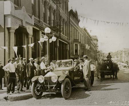
While reading through a massive pile of brochures, calling cards, guidebooks and other information from my six weeks on Route 6, I discovered a copy of a flier (date unknown) extolling the virtues of the new and improved "Great White Way."
Celebrating the Great White Way
Iowa, USA
In its old-fashioned furtive way, the advertisement asked, "Eventually, Why Not Now? The Great White Way By Day or By Night, The White Pole Route Between Des Moines, Stuart, Adair, Atlantic, Oakland, Council Bluffs, Omaha and Denver - Shortest and Best Route for Tourists."
I'd determine this ad to be from the mid-1920's, before the White Pole Road became US Route 6, when interest in auto-touring increased with the numbers of automobiles sold.
The flier goes on to gush, "The Great White Way is the best built, the best drained and the best kept road across Iowa. It passes through twice as many good towns and cities, is always near railway accommodations and telegraph stations, has more garages, has by far the fewest hills. Fifty thousand dollars has been expended to improve grades, build cement and steel bridges, the approaches to which have been and are the special pride of men who have established the Great White Way. All along the route are well improved farms and stock ranches - sites worth traveling a long way to see."
These farms and ranches are still worth traveling a long way to see. I never got over the thrill of seeing yet another looming, imposing, sky-high grain elevator up close, when I understood the phrase "our nation's breadbasket" in a more visceral, tangible way. Iowa, Nebraska and eastern Colorado are regions roundly ignored in most "Best of" or "Top Attractions" tour guides, and that's a shame. You'll learn a lot about our country, meet some great folks and be surprised by the inventive and creative thinking (not to mention some great food) in our country's mid-section.
Lately, localities along the former White Pole Road have been trying to revive interest in the route, which now parallels the fast-flowing I80. I found the following on the White Pole Road website:
In December of 1931, sections of our White Pole Road officially became a part of U.S. Highway 6, which at one point was the longest continuous east-west route in the United States stretching from Cape Cod, Massachusetts to Long Beach, California. In 1947, Iowa joined other states in officially designating US 6 to be named the Grand Army of the Republic Highway at the urging of an association of Union veterans of the Civil War. In 1965, Interstate 80 was completed and the popularity of this once important highway diminished.
US Route 6 is an important part of our country's history and present. I'm happy to have made the complete drive. And it will be a pleasure to round up my findings in my own Best of And Top Attractions lists. Stay tuned.....
Though I'm home, the road still calls. I won't be answering for awhile, with hearth and home, family and East Coast generating equal appeal. But it wasn't always so. An eon ago, while in High School, I gave serious thought to becoming a truck driver, so I could satisfy my desire to explore the open road while making a living at the same time. Back then, I'd listen to the song "Willin'" by Little Feat with welled-eyes - fully understanding the sentiments behind the words - "If You Show Me A Sign, I'll Be Willin' To Keep Moving." Little did I know back then, that The Sign would be the US Route 6 Shield!
Back in March, I wrote this post about the Route 6, Tonopah, Little Feat connection. In future posts, I'll feature Tonopah for reasons other than being in the trucker's anthem, "Willin."
Travel lists can seem contrived, arbitrary and even a tad gratuitous, but we all love them. So over the next couple of months, I'll be compiling my own "Best of Route 6" lists - and you can be sure that I've personally vetted every single place/person/thing that I write about. Why over the "next couple of months? Because I'll be traveling the globe until September and that's when I'll start to put my US Route 6 Guidebook together. Until then, I'll round up my experiences into small, managable Best of inventories including:
1. Best Watering Holes (Pubs, Saloons and Bars)
2. Hands Down Best Restaurant (I already have that one chosen and it won by a mile....stay tuned)
3. Best Hotel/B&B/Lodge With Incomparable Views
4. Most Outrageous, Larger Than Life Route 6 Characters
5. Best Route 6 Company Towns (with great factory/property tours)
6. Best Places to Discover Americana on US Route 6
7. Best Old Fashioned Soda Fountains on US Route 6 (Green River Phosphates, anyone?)
8. Most Surprising Discoveries on US Route 6
9. Best Hotel Amenities on US Route 6, Including Best "Wine and Cheese Afternoon Hour"
10. Most Historic Sites on US Route 6
11. Seven Natural Wonders of US Route 6
12. Best Sleepy Towns, Best Bustling Cities on US Route 6
International Quilt Study Center and Museum; put everything you thought you knew about the quaint, country art of quilting aside. The once homespun handicraft has risen to the level of academic study. With 3,500 quilts from nearly 30 countries, this fantastic museum and study center conducts genealogical and sociological research on antique quilts, and exhibits these intricate and amazing creations on a rotating basis. The new LEED contemporary building was designed to represent pieces of a quilt and it showcases these artifacts in the best possible manner. There’s an interactive room where you can record your own quilt story, and upstairs a soaring, temperature-controlled gallery where some of the oldest and best quilts the world has to offer are on display. Famous quilter, Grace Snyder used 80,000 pieces in one of her creations, and the museum has one of her works on display. “Quilts are so personal, so intimate, and a wonderful way to put a piece of yourself into a functional work of art to give to others,” said museum staff member Maureen Ose. A must-see even for non-quilters (like me) who will gain appreciation for the craft here.
Last month, I wrote the above about the International Quilt Study Center in Lincoln, NE. But I left out some very important information. The Center was founded in 1997 when Chappaqua, NY residents Ardis and Robert James donated 1,000 quilts from their personal collection to establish a museum and academic study center in Lincoln, NE (where Ardis was born).
Why am I revisiting this now? Ardis and Robert moved into a senior residence in my hometown - Stamford, CT - and according to today's New York Times obituary, Ardis passed away on July 7, 2011 just several miles from my house.
The world is richer for Ardis Jame's contribution to the art, craft and study of quilting. This post is in honor and memory of her.
Last month, I drove 3,652 miles from Provincetown, MA to Long Beach, CA on the longest contiguous federal highway in the United States - US Route 6. For months, I contemplated the logistics of the drive, and though I was eager and excited to journey alone, I did harbor some concerns.
As a travel writer, I'm very comfortable going solo. Being a woman without an entourage didn't bother me in the least (though I never advertised that fact on this blog). I never drove at night, booked either B&B's or safe hotels and was generally aware of precautions to take.
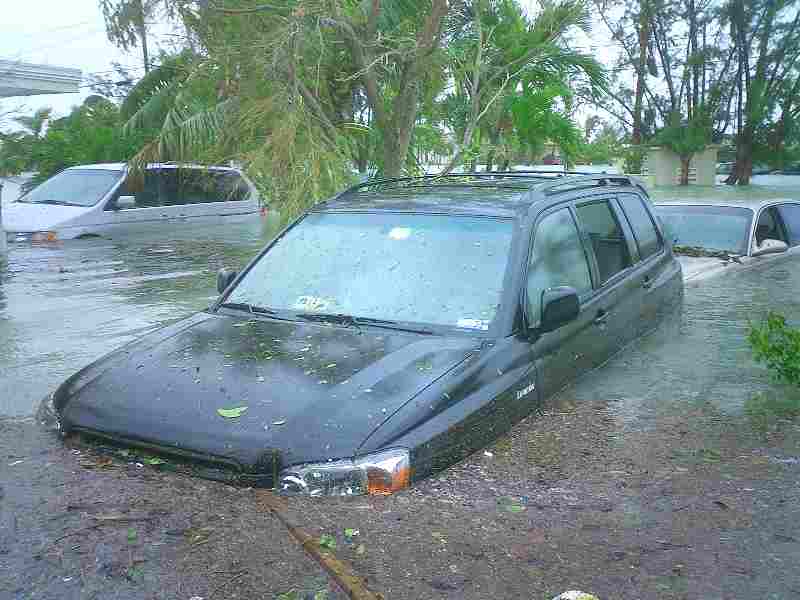
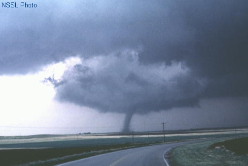
But I know that Mother Nature is not as predictable as Human Nature. She can whirl a deadly tornado or swell a river without a moment's notice, and so the following were the Natural Disasters I was lucky enough to avoid as I made my way across the country in nothing more than a piece of tin on wheels;
Aftermath of Freak Hurricane, Summer 2010
Stamford, CT
Hurricanes: These were the least of my worries, as I was burrowing inland West of Cape Cod. And anyway, most East Coast hurricanes occur in August/September.
Floods: Unprecedented flooding, especially in the Midwest, was big news when I left my home in on May 20th. I carefully watched flood reports in Council Bluffs/Omaha and heard that some roads there might be off-limits. Though I did witness rising water levels, I did not have to divert my own course.
Tornados; Fear of twisters kept me glued to the Weather Channel after a monster tornado took out most of Joplin, MO, two days into my Route 6 journey. As I approached Western Illinois and particularly in Iowa and the "tornado alley" of Nebraska, I became a TOR-CON (Tornado Condition) expert - assessing the possibility of a storm bad enough to spawn super cells and twisters. Fortunately, when bad (but not deadly) weather hit, it was usually during the night or before or after I got on the road.
Landslides/Falling Rocks; I had nightmares of boulders cascading onto my car as I drove through canyons and alongside mountain cliffs, especially on I70 in Glenwood Canyon where it's happened before. Fortunately, nary a pebble bounced onto my windshield, and the roads were free and clear of fallen rocks.
Earthquakes; This has been a seismically active season in the Pacific basin, and so it wasn't such a big leap to conjure up images of tumbling roadways and buildings in Southern California. Good thing the earth did not move for me while I hung out in Los Angeles for just over a day.
Now that I'm home, I won't have to run the weather gauntlet until my next road trip (which won't be for awhile; a lame way of saying, I have no idea when), but I do intend to absorb and process all of my great experiences across the country and will write about them from time to time. In the meantime, read past blogs and enjoy!
So, I’ve come to the very end of my cross-country, US Route 6 adventure. Almost. Time to negotiate the quagmire that is greater Los Angeles.
These are the directions I received, and I tried, I really did. I started out and ended well. But the middle was problematic. I’ll inject my own notations in caps:
Sierra Highway through Lancaster and Palmdale to Santa Clarita.
THE SIERRA HIGHWAY SHOULD BE A PREFERED ALTERNATE TO HIGHWAY 14. IT IS GORGEOUS, TOOK ME THROUGH HILLSIDE RANCHES, CANYONS AND AWAY FROM A SLEW OF FAST-MOVING CARS.
I STOPPED FOR LUNCH AT AN ICONIC LOCAL RESTAURANT IN SANTA CLARITA, THE BACKWOOD INN. LOW LIGHTING, SAWDUST ON THE FLOOR, STEAKS AND BURGERS, A FUN PLACE WITH HEARTY FARE.
South of Santa Clarita you get (TAKE A LEFT ONTO) on San Fernando Rd./Blvd. This will take you through the Cities of San Fernando, Burbank and Glendale to LA.
AND THUS BEGINS THE TRAFFIC LIGHT AND COMMERCIAL PORTION OF THE DRIVE.
In Burbank you will go around the Burbank Town Center. The original alignment once went through what is now the Burbank Town Center (shopping mall).
I WENT TO THE LEFT AND WENT AROUND THE MALL THAT WAY, BUT YOU CAN ALSO GO RIGHT AND AROUND THAT WAY- SAN FERANDO RD. CONTINUES ON AS IT WOULD HAVE HAD THE MALL NOT BEEN THERE.
From North San Fernando Blvd. to North Broadway through China Town.
THIS IS WHERE IT GOT CONFUSING FOR ME. THERE WAS SAN FERNANDO BLVD. THEN SOUTH SF BLVD, THEN NORTH SF BLVD, THEN IT WAS JUST SF BLVD THEN BACK TO NORTH SF BLVD. I SAW AN ARROW TO BROADWAY, TOOK THE LEFT AND FOUND MYSELF ON WEST BROADWAY.
I GAVE UP HERE AND RELIED ON MY GPS UNTIL I GOT TO LOND BEACH BLVD.
Turn right onto Alpine Street. Turn left onto N. Figueroa St. Now go south on Figueroa to the Pacific Coast Hwy. Go east on the PCH to Long Beach. Turn right on Long Beach Blvd.
I CAUGHT UP HERE. IT’s 20 MILES FROM DOWNTOWN LA.
Long Beach Blvd. ends at East Ocean Blvd. This is the westerly end of the Grand Old Highway. Congratulations!!
Across from you is the Long Beach Performing Arts Center. On the wall to the left of the entry is a plaque fronting the sidewalk. The plaque will note that this is the westerly end of 3,652 miles of the Grand Army of the Republic (Memorial) Highway.
FOUND IT!!! THE PLAQUE WAS DATED MAY 1953 – 11 YEARS BEFORE ROUTE 6 WOULD NO LONGER COME ALL THE WAY DOWN TO THE COAST.
I’m at the end of my trip – but my work has only begun. Stay tuned for LOTS more ROUTE 6 information – based on all the material and stories I’ve collected over the last 6 weeks!
I fly home this morning; my car has been shipped. It's been a great trip and I thank all who met me, helped me and guided me along the way!!!
From Bishop south, old Route 6 is but a memory. Though US Route 6 ran from Provincetown, MA to Long Beach, CA from 1937 – 1964, in ’64, California renumbered the routes, truncating Route 6 in Bishop. But there are still purists who try to recreate the former road, and I did attempt it and for the most part succeeded. I have to tell you, though that if you do decide to follow the Old Route 6 you will be amply rewarded. I stayed off the thruways as much as possible and was glad I did.
From Bishop, I took Highway 395 South through Big Pine, traversing outcroppings of lava chunks coughed up by the Eastern Sierras. My little car was blowing all over the road – there were Wind Advisories – as I headed straight into a dust-storm, impacting visibility.
In Independence, I made sure to visit the small, low-tech, but quirky Eastern Californa Museum. The curator took much delight in guiding me to the antique dentures, made for a human out of coyote teeth. So very weird. Other great exhibits include photos of Japanese Americans who were interred nearby at Mazanar taken by a fellow prisoner, Shiro Nomura, a collection of artifacts and photos from rock-climbing legend, Norman Clyde, “a disciplined intellectual who had the look and manners of a tramp,” and a terrific collection of Native American woven baskets – works of art, really. I’m telling you – it’s worth a stop just to see the coyote dentures.
A few miles south of Independence, I visited the Manaznar National Historic Site, where 11,070 American citizens of Japanese ancestrywere imprisoned. All of these people – adults and children alike – were taken from their homes and placed in similar camps all over the west. Not one was charged with a crime, yet some were confined for as long as 3 ½ years. Newscasts of the day called the packed trains to the camps a “voluntary migration,” and most who were instructed to go were told that they were being evacuated for their own safety, as animosity towards Asians skyrocketed after the bombing of Pearl Harbor. This was our country’s dirty little secret until President Ronald Regan signed a Bill of Restitution in 1988, calling these “war relocation centers” a “big mistake.” The Visitor’s Center is a must-see – with a 20-minute documentary that will break your heart. The land is so windy and bleak, I’m amazed that the prisoners there created schools, social societies, orchestras and the most gorgeous water-gardens. That they made the most out of their imprisonment is testament to the importance the Japanese place on culture and education.
Beverly and Jim Rogers Museum of Lone Pine
Film History, Lone Pine, CA
About 20 miles South in Lone Pine, I stopped once again at another can’t-miss museum; the Beverly and Jim Rogers Museum of Lone Pine Film History. It’s a long name for a relatively small museum, but when you watch the 20 minute documentary about the true Hollywood hills – the Alabama Hills just up the mountainside – you’ll understand why every single silent western, singing cowboy movie and later the movies that made John Wayne and Clint Eastwood household names all look the same – setwise. That’s because they were all filmed in these strange, rounded sandstone formations that were called the Alabama Hills. The museum is stocked with costumes, props and posters from Tom Mix, Gene Autrey. Randolf Scott, Wayne, Eastwood and others. Though now relatively quiet, every few years, directors get a hankering to film here. The terrain was weird enough to attract the producers of Tremors and Iron Man, and its still used quite a bit for TV ads.
Of course, I had to drive up into the hills (only 3 miles) to take a look at the formations. Freakish (leaning ghosts, cloaked lady,) but oddly familiar.
Outside of Oleancha, I started to see billboards for “Fresh Jerky,” and with such marketing prowess, I just had to see these jerky purveyors. Turned out to be a small, old converted gas station building covered with decals. In the middle of nowhere, they better advertise big! I bought the Teryaki flavor ($9 for a large vacuum packed bag) and hit the road again. Soon, a “wide load” truck carrying what had to be a 50 or 60 ft. yacht breezed by going north. Woa – looked more like an ocean-going vessel but perhaps a mega billionaire is carving out his own Great Lake.
Highway 395 traversed “China Lake” – I was coming into the hotbed (both literally and figuratively) of the aerospace industry. A billboard proclaimed “Now Hiring Scientists and Engineers,” which is a great thing for scientists and engineers in this economy.
Indian Wells Brewing Co.
Inyokern, CA
Still southward, 395 splits off towards the east, so here, I merged onto 14 south, (yes, formerly 6) where I discovered a great pit-stop; Indian Wells Brewing Company. This small brewery sits atop an Indian watering hole, which saved the life of many a pioneer back when this harsh land was being settled. It now turns out beers like “Lobotomy Bock,” “Blackout Stout,” and “Amnesia IPA,” along with uniquely flavored sodas. I tried the popular Mojave Red and it was very satisfying.
Red Rock Canyon SP
California
Route 14 slices right through Red Rock Canyon State Park, comparatively tame next to Glenwood Canyon, but striking nevertheless. I would have loved to have taken a Jeep Tour up into these red rocks, but I pressed on through Mojave (lots of planes on the ground, lots of wind turbines, lots of traffic lights, fast food and a big commercial strip), then, in Rosemond, I jogged left then right onto the Sierra Highway – the REAL original Route 6. Right away, I felt at home. I passed the familiar brown Historic Route 6 sign. I rode that Sierra Highway right into the big town of Lancaster, CA – a city on the verge of change….for the better.
Bordering Edwards Air Force Base, Lancaster is primarily an aerospace city, though it fell on tough times. In order to “bring Lancaster back” city officials decided to invest in downtown – to beautiful effect. Main Street – now renamed “The Boulevard” –looks like a tree-shaded park, and though not entirely pedestrian, it has the feel of a pedestrian mall.
EAT: I ate at a terrific “Farm to Table” restaurant, The Lemon Leaf, and had the best pizza since I left Connecticut. (Sorry Lemon Leaf – no one can top Pepe’s in New Haven, CT in my opinion). Across the street, the really funky, factory-like Bex (“Be Extreme”) serves “extreme” pub food; “extreme salads, extreme sandwiches” – and downstairs in the darkly atmospheric Underground Bowling Lounge you can try for strikes on neon-lit lanes. (Why are strikes good in bowling but bad in baseball?). On a Tuesday night, the place was pretty quiet, but I’d imagine (and would hope) it’s hopping on weekends. Outside, a live band was playing to a big group of bikers (Bike Night) and kids swung on tire swings in a clever side-walk space playground. A new Museum of Art and History is nearing completion, and the whole street has a very inviting vibe. Lancaster, CA plans to capitalize on the fact that Judy Garland got her acting chops here as a little girl when her family moved here from the Midwest. The small theater near her elementary school still stands (though it’s now a warehouse with a nice façade), and some city boosters would like to see it come back to life.
Lancaster also has one other very unique attraction – one that can only be found in two other places; Japan and South Korea. It’s a “Musical Road.” If you take a right off of the Sierra Highway onto Avenue G, and stay in the left lane, you’ll come to some grooves in the road. Pass over them at around 50MPH and you’ll hear the first five or ten seconds of the William Tell Overture. This “vinyl record” like method of music-making was created for a Honda Civic commercial a couple of years ago and freaks people out if they ride over it without warning. Very cool.
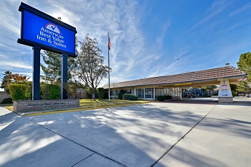
STAY: I would recommend the Inn of Lancaster even if they hadn’t put out a big sign welcoming “Malerie Yolen-Cohen On Her Route 6 Adventure” right outside the lobby. Oh my gosh, was that a surprise. (The bigger surprise came the next day when I was interviewed on camera for local and Los Angeles news stations. Gulp). Lancaster identifies strongly with the what used to be Route 6, the Sierra Highway, and though most people travel here on the parallel and faster Highway 14, The Boulevard is actually off of Sierra. And the Inn at Lancaster is actually ON Sierra Highway. Like several of the Mom and Pop motels I stayed in, the Inn at Lancaster is a wonderful, clean, comfortable and pretty place with lots to offer; a nicely landscaped outdoor pool, a complementary dinner in the early evening (hamburgers when I was there), a complimentary continental breakfast, and free Wi-Fi (always a plus). The Mom and Pop of record, Andy and Jeannie Holnberg, have a place to be proud of.