Thursday, June 30, 2011

Benton Springs, CA to Bishop, CA The Official End of Current US Route 6


Benton Springs, CA to Bishop, CA
The Official End of Current US Route 6


I’ve got good news and bad news regarding my photos.  The good news is, I took them. The bad news is that I’ve maxed out my allowed “storage space” on Blogger, which means that I can’t upload any more on my Route 6 blog for all time (or until Blogger increases its storage space.  More good news, however, is that I can still make and upload my videos – so I will somehow create a very fast slide show out of my still pictures, post the slide shows to YouTube and post them on my blog.  At least you’ll be able to see them.  Now, as I prepare to fly home to New York, I present the last three blog posts:

It’s just 36 miles from Benton to the end of current US Route 6, and for the first time since I began my road-trip in Provincetown, MA, I drove due South with the rising sun to my left.  I was in the valley between two mountain ranges – one craggy and snow-topped, the other wrinkled and grooved as a litter of Shar Pei pooches. I  entered a stretch with plenty of ranches and well-irrigated farms and with them the feeling that I was coming into “civilization” again.  That feeling was reinforced when I saw the mileage sign; 280 miles to Los Angeles. 

In Bishop – a lovely tree-shaded and mural-rich town popular with mountaineers, rock climbers and anyone who wishes to head into the Eastern Sierras with a guide and pack mules – two welcoming, friendly and terrific women met me under the “Route 6; 3,205 Miles to Provincetown, MA” sign.  Fellow Connecticut native, Patty Holton, President and the Bishop Mural Society and Ceramic Professor at Cerro Coso Community College, and Susan Olson, VP of the Bishop Mural Society, escorted me around to see some of the exceptionally skillful art-painted-on-the-side-of-buildings.  The newest soon-to-be-debuted mural is actually made up of ceramic tiles created by students and parents and represents the landscape, animals and flora and fauna from the 4,000 ft. elevation at the valley floor to the 14,000 ft. summit of Mt. Whitney.  It is a striking creation, and one I caught just being completed and grouted.  My photos barely do it justice.  All I can say is that it should be a tourist attraction. 


Mules figure prominently in Bishop; they now provide the brawn for overnight camping trips, but years ago, they were used in mining talc, silver and tungsten (used in light bulbs). One mural is a mining map of Bishop. Another shows a 1904 22 mule team pulling a massive water wheel as electric generator for Power Plant #3.  Interesting to learn that modern technology of the day made use of such primitive means of transport.  No surprise that Bishop celebrates its hard-working donkeys with a Mule Days Festival every Memorial Day weekend.

Melting snow from the mountains around here supplies most of the water for Los Angeles; a contentious subject in these days of water-wars.  Locals must get their water from wells, and a complex aqueduct carries the precious liquid nearly 250 miles South from the hills. 

Though I didn’t eat or stay in Bishop, Patty and Susan passed along suggestions for dining and lodging.  Jacks for breakfast, Whiskey Creek for lunch or dinner and the Creekside Hotel, they say, is “the nicest, swankiest place in town.”


Wednesday, June 29, 2011

Tonopah, NV to Benton Spring, CA on US Route 6


Tonopah, NV to Benton Spring, CA
81 miles


I just had to play the slots before leaving Nevada.  Amazing how fast $20 goes when pulling the 25 cent one-arm bandit a hundred times. 

Couldn't resist pairing Smash-Mouth's
"Who's There" with this segment of the drive.

Heading to Cali on Route 6; listening to “Alien Radio” – I kid you not – a great mixed bag of rock, country, pop of every age.  Oh yeah – THIS is the desert, baby.  Bring on the roasted animal bones and mirages.

Today, however, there’s lots of traffic.  Everyone is traveling mid-day. It’s the most congested on the road since I left Spanish Fork, UT.   A few miles out of Tonopah, I pulled into the beautiful Miller’s Rest Area – once a station and watering stop, now just a few shade trees, covered picnic tables, a water pump and bathrooms.  It’s amazing what an underwater source will do. Gorgeous.

Route 6 pairs with 95N here (not the Interstate, obviously), and I passed random upheavals of basalt and red sandstone hills. Otherworldly.


Once 95N peels off from 6 and I take the left towards Benton, traffic thins – though it’s still busier than yesterday.  The black blocks of lava, patches of white sand, snowcapped mountains, sepia mountains, dull green sagebrush and hazy blue sky put me into a kind of trance.  There are no jarring colors to perk me up.

Along the way, I see wild horses (there are plenty of Horse Crossing signs), and abandoned burned out buildings.  I can’t tell whether the structures were houses, motels or military installations, but I can tell they are very, very uncared for.  Gutted, charcoal, decayed.  There’s nothing on Route 6 except the relentless high desert and mountain landscape.

The small “Welcome to California” sign is shot through.  Who knows why.  Target practice?  Ironic considering the next billboard I see states; “Enjoy and Care for the Eastern Sierra.” I’m welcomed to California through a state Agricultural Inspection Station and with a few questions by an Ag. Official. Driving into the car-wash-like bay, I feel as if a) I’m entering another country and b) my car should emerge cleaner than it went in.  Neither applied.

Benton Springs B&B Hot Tub
Benton Springs, CA
In a few miles, I arrived at the one-pump gas station and 4 table café that is basically all of Benton, CA.  I had a good grilled cheese sandwich (my fallback when I’m unsure of meat and produce), and got directions to the Benton Springs B&B – just four miles up the road on Route 120.  It might as well have been on another planet; it was the loveliest B&B I’ve seen since Idaho Springs, CO – over a week ago.  Owned by uber-bicyclists, Diane Henderson and Bill Branlette (they bike all over the world for months at a time), it’s one of those places so good to be true it looks like a mirage.  Nine rooms (most with shared bath) ring a Spanish terra cotta courtyard and working fountain.  Guests can either eat in the café back in town or cook dinner on a grill and eat outside on a shaded patio.  There are three spring-fed hot tubs available for those who stay here.  Trees shading gorgeously landscaped yard - flowers everywhere - this is truly an oasis in the middle of the desert. 

Tuesday, June 28, 2011

Ely, NV to Tonopah, NV on US Route 6


Ely, NV to Tonopah, NV
168 Miles


This was the drive I was dreading the most.  168 miles/no services.  And yes, it was kind of scary, but now that’s it’s done, I’d do it again without trepidation.  The “unknown” is always the worst.

It was a beautiful, sunny early morning – 57 degrees 7am – when I took Route 6 where it splits with Route 50 in Ely.  I passed several cars heading the opposite way, and then, traffic became pretty sparse, though not nonexistent (I counted, believe me; I passed 50 cars going towards Ely over the complete 168 mile run).  Scarce, but not exactly “the loneliest road.”  

Signs blare: NO GAS FOR 167 MILES, and continue the countdown as if those sweating it out with near-empty gas tanks could forget.  I had plenty of bottled water and all the petroleum my car could take, so I was in good shape, range-wise.

Route 6 continued its mountain/valley/mountain/valley rhythm as it did yesterday, but the landscape was dustier, browner, more the bleached-skull-by-the-road desert than it was from Delta to Ely.  I passed several cattle ranches, cows grazing in the sagebrush, wondering how the hell they live on that stuff.  Desert cows puzzle me.

I climbed and descended through National Forests without one glimpse of a single tree, and a “Railroad Valley” without sign of train track or train.  I passed an oil refinery in the middle of nowhere (as everything is here), and a lone, lonely oil derrick pumping away. 

About halfway along, I got stuck behind two slow-moving trucks and felt oddly grateful for the company, until I realized the loads they were carrying were; “Radioactive.” Figures my much longed for company was toxic.  I passed them as soon as possible.

I entered strange territory; chuncks of lava were scattered by the road and mountain-sized mounds of dirt surrounded me.  It was like being in the Land of the Giant Moles.  There was a signpost for “Lunar Crater – and off to my right a feature that appeared to be a black lava field.  I didn’t turn off to investigate.  The whole area did look like a Meteor Impact field – a bit concave surrounded by heaved up hills. 

For the first time in 3,000 miles, I saw a “Dust Hazard” sign.  No worries about flooding and tornadoes here; it’s the sand in the air you’ve got to be wary of. 

Outside of Tonapah, NV
Tonapah is within the infamous Area 51 and the site of the Tonopah Bombing and Gunnery Range. The Stealth Bomber and other aircraft were tested at the Tonopah Airfield, which resulted in the stories that began back then about aliens and UFO, though there was nothing nefarious going on as I drove by.  I knew I was entering civilization once again when I passed the Tonopah Speedway and a small airport, and knew it for sure when, hot and dusty, I stepped inside a Burger King/ Subway/ Restroom Plaza near Tonopah crossroads, filled with high school age kids and travelers of all kinds.  My first impression of Tonopah was that it was a bit more accessible to plain ole non-gambling tourists than Ely is. 

Tonopah Historic Mining Park
Tonopah, NV
SEE: Tonopah was once the “Queen of the Silver Mining Camps”; from 1900 to 1912, mines here produced roughly two billion dollars worth of silver (adjusting for inflation) and there’s a very cool “ghost-town” like walking tour you can take of Tonopah Historic Mining Park.  On 100 acres set on the side of a hill, it’s a leg-stretching way to delve into this town’s past.  Wind blows through the remains of old mine shafts, headframes (the structures that held electric hoists), and miners shacks, and I swore I heard spirits of the dead whispering around the ruins.  Kind of spooky, really interesting, and very informative with great explanatory signage.  I was there a good hour plus.


Memorial to Airmen Who Died in Testing Accidents
Central Nevada Museum
Tonopah, NV
The Central Nevada Museum is also wonderful; what initially appears to be hunks of rusty junk in the property outside are actually relics of both Tonopah's mining and military history.  You can pay your respects to the military men who lost their lives in testing accidents at a memorial made from shattered pieces of airplanes and jets.  There's also a pot-marked granite boulder used in the mining jackhammer drilling contests in the early 1900's.   Walk the boardwalk of an old miner's town - miners cabins lining the dirt road - lizards skittering hither and yon. It's worth an hour of so to peruse.

I was having some computer issues again – my computer charger was broken and I couldn’t get on my Mac to write and post my blogs. I was bummed, but figured that I’d wait until I got home this weekend to complete my Route 6 travelogue.  I had only 4 days to go, anyway. But help came from a very unexpected place.


Sidewinder's Cafe
Tonopah, NN

My Hero - Travis Kaminski
Sidewinder's Cafe
Tonopah, NV
Awesome Sweet Potato Fries
Sidewinders Cafe
Tonopah, NV
I decided to try The Sidewinders Café for lunch; it didn’t look like much from the outside (right next to an abandoned Auto Parts store).  But there was a crowd inside, a funky wall with graffiti and well-wishes written by patrons from all over the globe.  And it had just opened two months ago.  Owned by Barb and Dave Kaminski (they have 7 kids, six of whom have been or are in the Army), it’s a great “home-cooked” lunch and dinner place with excellent sandwiches and sweet potato fries so terrific and crispy, I snapped a picture and posted it on Twitter!  One of the Kaminski kids, Travis, back from Iraq and soon to graduate college, was helping out at the restaurant and happened to be my waiter.  I told him about my frustration with my laptop and the broken charger and he smiled.  “You can use my Mac charger,” he said.  I was overjoyed!  So, I’d like to publically thank Travis Kaminski for his gracious offer – allowing me to blog on!  I took a picture of him and the first minute possible, I’ll post that, too.

Turns out that the Sidewinder was the best place to eat in town.  I tried a couple of suggested others, but they did not compare, so I can only recommend this one restaurant.  

Room at the Jim Butler Suites
Tonopah, NV
STAY:  Like my lunch place, the Jim Butler Suites didn’t look like much; a typical roadside motel.  But inside the adorable room, there’s a sitting area, a gas fireplace, a flat screen TV, and comfy bed with pretty, updated bedding.  The bathroom is the basic sink outside, toilet and shower behind a door kind of thing, but it’s much nicer than I expected and is right across the street from the Sidewinder Café and just a few blocks from the Mining Historic Park.  The manager/owner is extremely friendly, wi-fi is free, continental breakfast is complementary;  I’d recommend the Jim Butler heartily.


Monday, June 27, 2011

Delta, UT to Ely, NV on US Route 6


Delta, UT to Ely, NV
155 miles


Woke up early to get on the road when it was still cool out; 7am. I didn’t want to get stuck in the desert with the 110 degree sun beaming down on my little car.

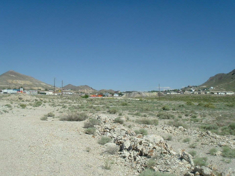
I’d imagined this drive to be sandy desert, some rocks, bleached animal skulls by the road – you know – the big bad Southwestern Desert.  But this wonderfully diverse portion of Route 6 surprised me.  First of all, there was lots of green.

Of course, the green was mostly sagebrush, but some of it was farmland (mostly in Nevada) – another surprise.  A couple of miles west of Delta, a jackrabbit crossed my path.  I took that as a good sign.  The road for awhile was mostly flat.  I saw the sign for the “U-Dig Fossils, 20 miles” cut-off and realized I had too much to see in Ely to spend the morning hunting for trilobites.  But last night, I met a family of 5 (three young girls and their parents) who came to Delta from Denver specifically to rock and fossil hunt.  This area of the country is rich in fossils – they’re just lying all over the place if you know where to look.  They had planned to go to U-Dig today, and I hope they were successful.


US Route 6/50 Between Delta, UT and Ely, NV
In contrast to my flat, relentless desert drive fears, Route 6 from Delta to Ely, NV runs through a succession of valleys and mountains (basins and ranges).  For over an hour, I had the road pretty much to myself and felt like the last person on earth.  For over 80 miles, there were no mining operations, no farmsteads, just utility poles, an occasional orange trash can and the road – the only imprints of man.

Border Inn
Border of Utah and Nevada
on US Route 6
Up, around and down through the mountains – it’s a beautiful drive. Route 6 snakes around boulders, through road cuts; there are excellent spurts of fun driving.  As soon as I crested the first hill, I saw snowcapped mountains ahead.  Down in the Valley, over 80 miles from Delta, I pulled in to the Border Inn, where you don’t have to wait a split second to start playing the slots.  There are motel rooms, pool tables, a restaurant, a gift shop – and gas.  I’m sure the place is quite the relief to those who thought they’d fallen off the edge of the world.

It is the border, and of course – right on Route 6/50 there’s a big Welcome to Nevada Sign.  There’s also a nice big green Army of the Republic Highway (another name for Route 6) sign.  Yay!  This is a designated “Scenic Byway”, and I could see why.  Basin. Range. Basin Range.  I’d drive on flatland for awhile, then rise up into a mountain range, snake around and through rock faces for awhile, descend into flatland again. Repeat.  It was lots of fun.  The Baker Archeological Site is off of here, as is the entrance to the Great Basin National Park (12 miles off 6).  As the morning progressed I started to see a lot more traffic; campers, RV’s motorcycles, SUV’s.  I had so much fun driving, I’d forgotten how nervous I’d been.  Soon, I began to see homes, and 5 acre lots for sale, but no sign of any town.  On the flat portions of the road, I was going 70 and it felt as if I were standing still. 


Major’s Place shows up on my map as a little dot – a nothing town.  But it’s not even a town.  It’s one PLACE.  A roadside café kind of place.  I was just about to drive past it when something told me to go inside.  I’m so glad I did – because now I can tell all of you to do the same.  It’s a pub so quirky, you’ll just have to see it.  Built of logs, over-decorated with antlers and animal heads (at least one with a cigarette in its mouth), and walls and ceiling covered with over 1,000 dollar bills from patrons who come from all over the world, Major’s Place is too cool to miss.  Ely is only 28 miles away, and many people make the drive to eat and drink here.  It was too early in the morning for a beer, otherwise, I would have stayed.

Ward Charcoal Ovens
Ely, NV
About 18 miles east of Ely, I turned left to see the Ward Charcoal Ovens.  It’s definitely worth kicking up 7 miles of dust on a dirt and gravel road to see these out-of-place structures.  Like giant bee hives, the six 30 feet high ovens were built by Italian masons in the mid-1870’s.  They were used to make charcoal to fuel the once-nearby silver ore processing furnaces.  A plaque states, “These are a unique and silent reminder of Nevada’s Mining Industry.”

Mural in Ely, NY
Ely is an interesting mix of characteristics.  A community of 4,000, it's got the casino's, legalized prostitution, but Ely also has an "Art Trail" - a couple of dozen excellent murals and sculptures scattered on buildings around town.  Most of the gamblers could give a hoot about the art, and I suppose many who come for the terrific Steam Engine train ride and Art Trail give the casinos a wide berth.  

Nevada Northern Railway National Historic Landmark
Ely, NV
DO:

Lennox Purinton and Grandpa Don Purinton
Nevada Northern Railway "Keystone" Excursion
Ely, NV
The Steam Train excursion at the  Nevada Northern Railway National Historic Landmark is a major draw for Ely.  I took a 1 ½ hour ride to Keystone pulled by an 1908 Engine 93, “built for power, not for speed.” It was once used to haul ore to the smelter, retired in 1950, and now the old guy hauls tourists.  On board, I befriended a loquacious 8-year-old named Lennox Purinton, dressed as a Breakman, who knew everything about trains. (pic soon, I hope).  His grandpa, Don, was the volunteer conductor, so no surprise. “Grandpa started me when I was two with Thomas,” Lennox told me.  “In a month, I knew the names of all the trains.”  It was nice to have someone else drive me for a change – and as I watched the scenery go by, I saw a few cars by the side of the road – people stopping to take pictures of Ole Engine 93.  The excursion stopped, then returned from the huge mountains of dirt that are the tailings from the very productive operating Copper Mine, now owned by Quadra FNX. The new mining company brought hundreds of jobs back to Ely, so things are turning around here.

Don and Susan Bowers
Ely, NV
Afterwards, I met the man who had narrated the trip, Don Bowers, along with his very nice wife, Susan, at the Silver State Diner – which serves great French fries and good basic food.  Don let me know that if you are a train fanatic with an extra $700, you can actually run a steam or diesel train yourself for a couple of hours. You have to read some material, pass a written test, and run the engine with an engineer present.  Apparently, this is a very popular offering, and a way for the city to keep this attraction going.  Don and Susan also said that the October “Ghost Train” and November-December “Polar Express” are incredibly popular, often selling out well in advance. 

Ely Renaissance Village
Ely, NV
I also visited Ely Renaissance Village – and, along with the railroad and charcoal ovens, this is another worthwhile Ely attraction.  Because of ranching and mining, Ely has always been an ethnically diverse city.  Renaissance Village celebrates this diversity by showcasing five authentic Rail Kit Homes, and two shot-gun style houses, as if each was owned by a family of a different nationality.  These homes are kept circa 1915, and feature original linoleum floors, wood stoves and indoor plumbing including flush toilets – rare for the day.  Each home features a sign that says “Welcome to Our Home” in the owner’s national language; English, French, Asian, Slovic, Italian, Spanish and Greek.  Décor was painstakingly researched – down to the color of the walls – and so well done that when travelers from those countries come here, they enthuse, “this looks just like my grandparent’s house!” Such a unique way to honor people from around the world who made their home in Ely.
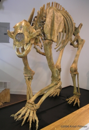
"Lilly" the Cave Bear
White Pine Public Museum
Ely, NV

If you have a few extra minutes and its open, stop into the White Pine Public Museum – a Grandma’s attic if there ever was one, but with a few interesting gems – like a Wells Fargo Stagecoach Lockbox, the model of Lilly – a 12,000 year old Cave Bear, a xylophone found in an abandoned mine, and the requisite cabins and one-room schoolhouses outside.

Cell Block Steakhouse in the Jailhouse Casino
Ely, NV
Eat: I had a good meal at the only "fine dining" establishment in Ely - the Cell Block Steakhouse at the Jailhouse Casino.  Each table is set within its own cell, which is both intimate and isolating (though perfect for romantic couples).  My lamb chops were very good.  From all accounts, this is the best restaurant around.


Mickey Rooney Suite at
Hotel Nevada,
Ely, NV
Stay:  Hotel Nevada.  Steeped in history, this six floor hotel and casino was the tallest building in Nevada when it was built in 1929.  It was also half way from Hollywood to the glam Sun Valley Ski Resort, so celebrities of the day would stop here overnight.  That history is marked both inside and outside the hotel (the sidewalk outside features names of stars, and many guestrooms are named for the notable who chose them).  I stayed in the light and airy “Mickey Rooney” suite, done in Irish green, and filled with pictures and posters of the baby-faced actor.  It’s not posh by modern standards (the small sink sits in the bedroom itself), and the hot-cold-at-random shower shows its age, but it’s clean and fun (though I’m not sure what a pink plush bear on my bed has to do with Rooney), and I utterly enjoyed it. Each Suite comes with a complementary beer across the street and a complementary margharita at the bar downstairs.  Had I not been so wiped out, I would have sipped on a drink and sunk my coins into the slot machines on the first two floors where the bells and lights and beeps and bleeps went on all through the night (though my room was very quiet).


Sunday, June 26, 2011

Price, UT to Delta, UT on US Route 6


Price, UT to Delta, UT
162 miles


West of Price, I’m thrust right into the Western end of the Bookcliffs; sandstone weathered into blocks and folds, like Mother Nature’s Mount Rushmore.  It’s imposing and more magnificent than I expected it to be.  Though the stone looks so loose as to tumble or slide down to the road any minute.

Storefront; Helper, UT

Helper, Utah

Post Office Mural; Helper, UT

Old Vacant Movie Theater; Helper, UT

Downtown
Helper, UT


Mining Drill Bits
Western Mining And Railroad Museum
Helper, UT
Photo of Child Miner
Western Mining And Railroad Museum
Helper, UT
Helper, UT is a few miles up the road.  Named for the strong engines that would “help” the larger trains up the mountain to Soldier’s Summit, it was all but a ghost town a few years ago.  But Union Pacific still has a presence here, and there are a couple of window-only art galleries trying, trying, like the Little Helper Engine That Could, to try to make a go of it in this sandy mountain desert town.  To emphasize how behind the times renovation is here, the Strand movie theater still has a “Now Showing” poster for “Anna and the King of Siam.” There’s a nice WPA mural in the soon-to-be-closed Post Office, done, I was told, by one of two sisters from Rifle, CO (a Route 6 town) who typically painted these murals all over this area together.  When one died, this was the first solo painting done by the surviving sibling.  There’s lots of history here, mostly mining and train – and you can get a good taste of it by stopping into the chock-a-block Western Mining and Railroad Museum, located in the former 1914 Helper Hotel.  Though displays are haphazard at best, there are three reasons to visit; one – it’s cool to wander around four floors of an old mining town hotel, peeking into different rooms each with its own (mostly local interest) themes, like the Kiwanis Club, yet other pretend shops and offices, and lots of old mining equipment.  Two – there’s a fascinating display of old photographs of kids, some who don’t look more than 5 years old, donning miner’s.  One in particular still looks like a toddler, and he’s smoking a pipe.  Obviously, this was prior to Child Labor Laws, but I couldn’t help thinking how fast children grew up back then and in these conditions.  The third reason to come to this quirky museum is for the awesome, new bathrooms!  All road-travelers place a good deal of emphasis on potty-breaks, and this place has one of the best I’ve seen.  Helper has one nice-looking restaurant – the Balance Rock Eatery.  I was there too early in the day for lunch, but I heard it’s good and seems to be the only game in town.

Tie Fork Rest Area
West of Soldier's Summit, UT

Tie Fork Rest Area
West of Soldier's Summit, UT
Tie Fork Rest Area
West of Soldier's Summit, UT
West on Route 6 out of Helper, the road constricts into a narrow canyon cut.  Traffic slowed (thank goodness) due to roadwork and one-lane stops, and there was a lot of it.  It’s 58 miles to Spanish Fork – and I15 merge from here – and there was lots of truck and recreational traffic. It’s really a grand drive on this portion of Route 6.  I had been so worried about the “Deadliest Road in America” label that I never even considered that it would be so stunning; up and up to Soldier’s Summit, there’s a gas station, snow-capped mountains before me, and a sign that pegs the former train town at 7,477 ft.  elevation.  On the way down the hill, there’s a great new rest stop; Tie Fork Rest Area that’s a bit of a train Round House museum (I heard a Dad explain the roundhouse to his 4 year old son in “Thomas” terms) , a bit of a Visitor’s Center, a bit of a picnic area and again, great toilets. Lovely amenities on Route 6 in seemingly the middle of nowhere. 

In Elberta, Utah
Rolling down into a vast valley, all of a sudden….it’s Switzerland!  Verdant hills surrounded me, a bit of a shock after all that sandstone and brown, brown, brown.  I was approaching Spanish Fork – a “bedroom community” of Provo.  And sure enough, here came the fast food joints, shopping centers, roads going hither and yon.  I looked for and found a closed Daughters of Utah Museum– only open on Mondays, so I continued on Route 6 and found myself merged onto Interstate 15.  There’s no Route 6 sign indicating that you must veer South on 15, but you must.  I drove quickly through Payton and then peeled off the thruway in Santaquin – Exit 244.  Ahhh. Two lanes and quiet driving again – and thanks again, Utah – the Route 6W exit sign is clearly marked.

There were bunches of bicycle riders as I made my way West.  From here, it was 72 miles to my next overnight stop: Delta.  I drove through the farming town of Goshen (yep, back to farms and back to a bit of green), the half-blink ghost town of Elberta where I snapped a picture of an old Sinclair Station, then up again into the hills where the air and traffic thinned considerably. 

Tintic Mining Museum
Eureka, UT


Lyman Davis
Tintic Mining Museum
Eureka, UT
While driving through the nearly abandoned downtown of Eureka, I spied an “open” sign on the Tintic Mining Museum door.  So I stopped and went in, and met Lyman Davis who was born and raised here, lived in California for 30 years, then “came home.” He was a font of information about the mining done in this area.  “Eureka, I found it!” did not refer to coal, of course.  There was lots of gold, silver, copper, lead and zinc taken from the ground here; over $600 million dollars worth.  No longer. There are plenty of shells of mines and mills in these hills; “someone would always be coming up with a better process,” Lyman said.  The museum contains some amazing photographs of miners and thigh-wide veins of gold in the richest rock along with an incredible sculpture of a miner that looks out of place here.  I bid farewell to Lyman and he told me to “drive careful….the rest of ‘em don’t.”

I passed Wide Load trucks carrying Army tanks, and shared the road with one lone tanker truck for awhile.  I passed a sign for “Little Sahara Sand Dunes” – which gives you an idea of the landscape here.  I could see and feel my skin drying up.  If you’re so inclined, you can ATV there or just hike the dunes.  I pressed on.

Red Rock Cheese Shop
Delta, UT

Anita Nilson, Owner
Red Rock Cheese Shop
Delta, UT
Red Rock Cheese Shop
Delta, UT
On the outskirts of Delta, I passed a nicely groomed golf course (a Country Club!), and then the most improbably situated cheese shop in the country.  Or at least on US Route 6!  A cheese shop?  In this hot, punishing part of the country?  Yep.  The Red Rock Cheese Shop, owned by Anita Nilson, also makes cheese.  You can watch the process from an observation window and sample the dairy goodies, too.  Red Rock turns out both Goat and Cow cheeses, and something called “curds” which is apparently big in the Midwest.  Curds are the biggest sellers in the store (she gets lots of travelers on this road), though she ships more Fetta than anything else.  Anita told me that though she’s the only cheese-maker in Delta, there are other dairies and cheese makers in the area.  Very cool.

Camp Topaz Baracks
Great Basin Historical Society and Museum
Delta, UT
Before checking in to the Days Inn for the evening, I made one last visit to the Great Basin Historical Society and Museum.  This is where I discovered part of our nation’s dark past.  This museum has an exhibit about “Camp Topaz” – which was located about 15 miles from Delta.  It was an internment camp during WWII for 8,000-10,000 people of Japanese Ancestry, most of whom were US Citizens.  Outside, the museum maintains one of the camp barracks, and it’s a sad place.  The museum itself is another hodgepodge of set-up rooms, rocks and minerals, and a nice grouping of fossils found in the area.  We are in the “basin” portion of the West – formerly covered by water – and so rock-hounds come to dig for trilobites and other ancient sea animals found in profusion around here.  There’s also a display about Berylium – stronger than steel and lighter than aluminum. This, apparently, is the only area in the world with mineable quantities of the stuff. 

The Days Inn, Delta, UT is pretty much the only game in town for a decent night’s stay.  Rooms are dated and Spartan, but the hotel offers complimentary breakfast and maintains a beautifully landscaped outdoor pool and picnic area.  I just had to take a dip on a glorious hot evening, right after walking over to the Mi Ranchirito Mexican restaurant next door.  I didn’t expect anything – just a basic TV dinner type meal – but was pleasantly surprised.  My “marinated steak” strips were tasty, service was friendly, and the diner-type room cheerful.  Not haute, but filling and well-prepared.  A surprisingly nice evening in a place I thought was in the middle of rocks and sand.

Saturday, June 25, 2011

Green River, UT to Price, UT on US Route 6


Green River, UT to Price, UT
62 Miles


From the hotel strip that is Green River’s Main St, I got back onto I70 for three miles before seeing huge signs for Route 6W/191.  Utah rocks.  And, I mean that in every way possible.  I got off on Exit 157 and found myself surrounded by brown, hazy, desolate scenery in short order, and thus it remained for nearly 60 miles.  I had plenty of company, though.  Many cars, trucks, buses, motorcycles and RV’s were whizzing by heading South.  This is a major route and this portion of Route 6 at least is not “the Loneliest Highway.” (That comes in a couple of days). There’s a lot of work being done on the road – it’s been widened in dangerous spots (Route 6 here used to be considered one of the deadliest roads in the nation), and looks like it will be widened and improved in others.  A friendly flagman joked that I’d have to wait “an hour” at his stop sign, then he turned it over to Slow and let me go. 

I passed a stuck-in-the-past abandoned gas station – the price of gas fixed in time at $1.89/gallon.  Those were the days.  I also passed a brown sign pointing to a Dinosaur Quarry, which struck me as funny.  Why not dinosaur Archeological Site?  Or dinosaur dig?  Were desert landowners quarrying dinosaurs for great kitchen countertops? Those certainly would start some conversations.  I want one.

Prehistoric Museum
Price, UT
Soon, I began to descend into a green oasis-like area.  This was the small town of Wellington, just a few miles East of Price, and the first sign of civilization in 60 miles.  There’s a slew of no-tell motels (one called “Pillow Talk” – wonder what goes on there?), churches, and the “Cowboy Kitchen” – home-cooking café.  “She’s Acting Single so I’m Drinking Doubles,” was playing on the radio.

Soon, the larger city (8,500) of Price was in view. There are movie theaters, restaurants, shopping centers – it kind of took me by surprise after all that remote desert driving. 


Columbian Mammoth
Prehistoric Museum
Price, UT

Native American Diorama
Prehistoric Museum
Price, UT
My first stop was the very good Prehistoric Museum; it’s where some of those quarried dinosaurs ended up (others are sent to museums all over the globe).  According to the museum’s director, the institution has undergone a name change (once the CEU – College of Eastern Utah – Prehistoric Museum, the name was shortened so as not to confuse people), and has its hands in everything from “discovery to digging to displays….we do it all!”  She went on to tell me that the area around Price is rich paleontologically, geologically and archeologically.  Scientists from around the world come here to explore.  In 1988, a Columbian Mammoth was unearthed here (less hairy than it’s wooly cousin), and people from as far away as Japan come to see the recreated skeleton as well as actual bones from the also-locally discovered Utahraptor; a little fierce creature made famous in the movie Jurassic Park.  Besides the dramatic re-creations of dinosaur skeletons, utilizing some of the unearthed bones, the museum showcases “projectile points” – defined as any pointed object attached to a spear, lots of Native American artifacts, and dioramas.  Also, there are two observation labs; one for paleontologists, one for archeologists, with sliding windows that visitors can open to ask questions of the working scientists.  Allow for at least 45 minutes in this two-story museum.

Cute Gift Shop: Wild N'Bellish
Price, UT
Price doesn’t have an artsy vibe, but there’s a sense of growth in the air.  I spoke to the owner of the incredibly fun gift shop, Wild N’Bellish (corner of Main St. and Carbon) and she mentioned that the three towns of Wellington, Price and Helper are indeed going through a growth spurt.  And Helper – just a few years ago written off as a ghost town – is now a magnet for artists.  (More on that when I get there tomorrow). 

EAT:

Main St. Grill Ice Cream Bar
Price, UT

For lunch, eat at Main St. Grill.  You can get a half-sandwich (basic, but good), and Salad Bar for under $9.  A variety of lettuce and fixin’s are super-fresh, and the salad bar includes home-made soup AND soft-serve ice cream with plenty of candy toppings.  I had to hold myself back. 


Price, UT
Anthony J's Restaurant
Price, UT


Grogg's
Price, UT
Main St. Grill Salad Bar
Price, UT
As for dinner, pickin's are slim in Price - though I'll mention two places I tried and might recommend in a pinch;  Anthony J's on Main St. is Price's answer to a "fine dining" experience.  The dining room is a dark, atmospheric cellar/speakeasy, and serves typical steakhouse/seafood/pasta dishes.  The waitress got my order wrong, then blamed me (I was presented with a cow-sized piece of steak, when I ordered the "petite"), always a no-no in the service profession.  But people seem to like this place, and the all-inclusive prices are right (under $20 for a full dinner that includes salad, soup, main entree and potato), so as I said....in a pinch.  The other very popular place is a bit out of town on Carbonville Rd; Grogg's, an outpost of the beer-maker, Pinnacle Brewing Co.  I probably should have planned to have dinner there - it was hopping, both outside on the patio and indoors where babies to senior citizens were enjoying burgers and craft been on tap.  My "Shock Top" - a Belgian Wheat - was fresh and wonderful.

STAY;  I can't really recommend the place I bunked down for the night. Shortly after I arrived a maintenance man barreled into my room without knocking.  (He apologized profusely, but it shook me up, and did not bode well).   Let's just say that the Holiday Inn in Price needs updating and staff service training in order to command its undeserved lofty rates ($130 for the night; and I'm a "preferred customer!)  The fact that breakfast does not come with the room (as it does in Holiday Inn Express brand), and powdered eggs and bland "homefries" (plain potato shreds right out of the freezer) cost good money here, I'd say skip it.